Pre-Union ca 1600 Scottish Border Army


https://www.familytreedna.com/social-photos/4498710?dpr=2&fit=max&h=348&w=590


Steel Bonnets In Debatatable Lands with George Macdonald Fraser and Eric Robson

Clan Elliot – Wikipedia, the free encyclopedia
File:Sasine deed 1484 for Robert Elwald (Elliot), Redheugh, Larriston, Hartsgarth.jpg – Wikipedia
Proto-Germanic R-U106 haplogroup DNA Elwald-Elliot – Gorrenberry
sheep-stealers-from-the-north-of-england-the-riding-clans-in-ulster-by-robert-bell PDF
Clan Elliot – de.Wikipedia.org Germany
Steel Bonnets In Debatatable Lands with George Macdonald Fraser and Eric Robson


Appendix-H-Rowell-Charles-Carroll.pdf


مدرسة الفرندز رام الله
iew.jpg”>


How family members are being successful at family history;
THE FAMILY KNOWS BEST.
LISTEN TO OTHERS, ESPECIALLY PEOPLE OF THE OPPISTE SEX, WHEN IT COMES TO FAMILY.
WHEN FINDING FAMILY DO NOT GET RID OF THE IN-LAWS EVEN IF YOU WANT TO.
FAMILIES FIGHT, THOUGH DISAGREEMENT, BOTH POSITIONS-ANSWERS ARE LIKELY CORRECT.
IF THE FAMILY’S HISTORY IS DONE PROPERLY, ONE DO NOT GET TO CHOOSE THEIR RELATIVES THEY AR BORN WITH THEM.
THE FAMILY KNOWS BEST. Anything which is presented as pasted down as family history by a member of the family is accepted as being correct. If someone not of the family line expresses it being incorrect, they may be a historian, but not a family historian.
LISTEN TO OTHERS, ESPECIALLY PEOPLE OF THE OPPISTE SEX, WHEN IT COMES TO FAMILY.
People of the opposite sex see things differently and will offer a different perspective when seeking information about family.
WHEN FINDING FAMILY DO NOT GET RID OF THE IN-LAWS EVEN IF YOU WANT TO. If there are relatives that you do not want to be related to, put them in because they may be linked to relatives you want to be related to.
FAMILIES FIGHT, THOUGH DISAGREEMENT, BOTH POSITIONS-ANSWERS ARE LIKELY CORRECT. Any information you may receive is helpful, and is likely as correct as ones own.
IF THE FAMILY’S HISTORY IS DONE PROPERLY, ONE DO NOT GET TO CHOOSE THEIR RELATIVES THEY AR BORN WITH THEM. (self explanatory).

مدرسة الكويكرز الفلسطينية التي صمدت 150 عامًا من الحرب والاحتلال – كويكر سبيك
تأسست مدرسة أصدقاء رام الله عام ١٨٦٩ على يد اثنين من الأصدقاء من نيو إنجلاند، حين كانت فلسطين لا تزال تحت الحكم العثماني، وتوسعت لاحقًا لتضم حرمين جامعيين في مدينتي رام الله والبيرة المتجاورتين. وقد أجرت QuakerSpeak مؤخرًا مقابلات عبر تطبيق زووم مع رانيا معايه، مديرة المدرسة، وعمر تسديل، أمين مجلس أمنائها.
صمدت المدرسة لعقود من العنف خلال الاحتلال الإسرائيلي للضفة الغربية، بل وتعرضت لهجمات في بعض الأحيان، لكنها ما زالت مزدهرة. يقول عمر: “عندما يبدو الأمل معدومًا، نسعى جاهدين لتوفير ملاذ آمن يشعر فيه الناس بالترحيب والحرية، بينما هم خارج أسوار المدرسة ليسوا أحرارًا على الإطلاق”.


Family Tree DNA social photos 3719534 (1181×912)


American Friends Service Committee – Speed read – NobelPrize.org

Family Tree DNA social photos 3730883 (1180×884)
Family Tree DNA social photos 3712452 (1180×598)
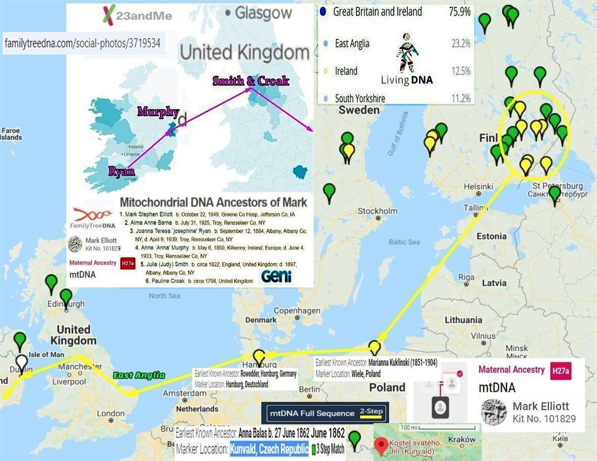
Поскольку у меня нет доступа к набору FTDNA №101829, пожалуйста, используйте набор YSEQ №4069, чтобы найти для меня семейного историка Марка Стефан Эллиотта.


Family Tree DNA social photos 3730883 (1180×884)
Family Tree DNA social photos 3712452 (1180×598)
Поскольку у меня нет доступа к набору FTDNA №101829, пожалуйста, используйте набор YSEQ №4069, чтобы найти для меня семейного историка Марка Стефан Эллиотта.


On Will of Robt Elliot and family, New Castle, Kittery, Maine b. 1643 by MSE 5/23/2012

Fathers-Father-4-Robert-Elliot-and-Colonial-Maine-Royalists.pdf MSE
Chasing-my-Y-DNA-part-28.pdf MSE

Difficult to Transcribe plus Confusion and a Result with Clarification-1.pdf MSE-7-19-2012


File:Sasine deed 1484 for Robert Elwald (Elliot), Redheugh, Larriston, Hartsgarth.jpg – Wikipedia
Armetage-Hermitage-Armestrang-Armstrong-Castle-Bothwell.jpg (1030×960)


FTDNA–social-photos-3719534.jpg (1181×912)


Fathers-Father-4-Robert-Elliot-and-Colonial-Maine-Royalists.pdf MSE
Chasing-my-Y-DNA-part-57.pdf MSE 3-27-2013


A true and exact history of the island of Barbados | Project Gutenberg


Scottish Poetry Selection – Wha Daur Meddle Wi’ Me?
The royal coat of arms in Scotland has the Latin motto “Nemo me impune lacessit“. The English translation of this is “Nobody interferes with me with impunity” and this is often defiantly expressed in broad Scots as “Wha daur meddle wi’ me?” which is the title of this anonymous poem. But on this occasion it is being aggressively repeated by a member of the Elliot family, one of the Border families who not only fought their neighbours but were part of the first line of defence against marauding English invaders – and could sometimes defy the Scottish monarch as well!


File:Sasine deed 1484 for Robert Elwald (Elliot), Redheugh, Larriston, Hartsgarth.jpg – Wikipedia

File:Crozier and Elliot in Upper Liddesdale Blaeu 1654 map.jpeg – Wikipedia


https://www.familytreedna.com/social-photos/3719534


Tullykelter-to-America 3/1/2012 Mark Elliott PDF


Elwald-de-Armstrong PDF


File:Sasine deed 1484 for Robert Elwald (Elliot), Redheugh, Larriston, Hartsgarth.jpg – Wikipedia


Elwald-de-Armstrong PDF


Peace On The Border
After the riding we dispersed We drifted home in twos and threes Through cold and rain we spat and cursed This ancient war of families


In Barbados Anglican-Royalist Scot POW from the English Civil War 1650 were indentured to the Barbados Plantation, this a precursor to the African slaves.


В этот бесценный момент во всей истории человечества все люди на этой Земле поистине едины – едины в своей гордости за то, что вы сделали, и едины в своих молитвах о вашем благополучном возвращении на Землю.
АСТРОНАВТ АРМСТРОНГ. Спасибо, господин Президент.
gbnames.publicprofiler.org, ( named.publicprofiler.org, forebears.io/surnames ) for 1881 it will show that the ancestors of the Pre-Union Scottish Border Army are still at their location to defend the border, in 1881 and are likely still there today.
Names taken from RP Elliott research,
minimums of Elliot, Kerr, Burns, and Dixon;


Elliot (border form);


https://www.peopleofthebritishisles.org/
http://named.publicprofiler.org/
Kerr;


https://forebears.io/surnames/Ker
https://forebears.io/surnames/Kerr
https://forebears.io/surnames/Carr
Dixon (son of Dick; Richard);

Nixon (son of Nick; Nicolas) similar distribution to Dixon.


Burns;


By R-U106;
Scot, Bell, and Johnston added;

Scott;


Bell;


Johnston;


Added from Saxton 1576 map with peel towers;

Graham;


Armstrong;


Forester Forest (occupational);


Added from 1590 map of Liddesdale;
Crozier are in North Liddesdale, name is occupational means cross bearer.


One can see strong in Liddesdale, like Elliot.

Thomson


https://forebears.io/surnames/Thomson
and Rutherford;


Added from Redheugh-Lariston-Hartsgarth sasine (deed).
Crosar is Crosier, Grame is Graham, Forstar is Forest/Forester, Ker is Kerr, Scot is Scott, Elwald is Ellot/Elliott, and Gledstanys is Gledstanis is Gladston;
Gladston;

Eastern Border, the Fairbairn and Hume;
Fairbairn;

,_Redheugh,_Larriston,_Hartsgarth.jpg)

Hume;

Hume receiving land in Minto-Wolflee/Wolfhopelee region.
Apologize for those borderers left out.
Try for more;
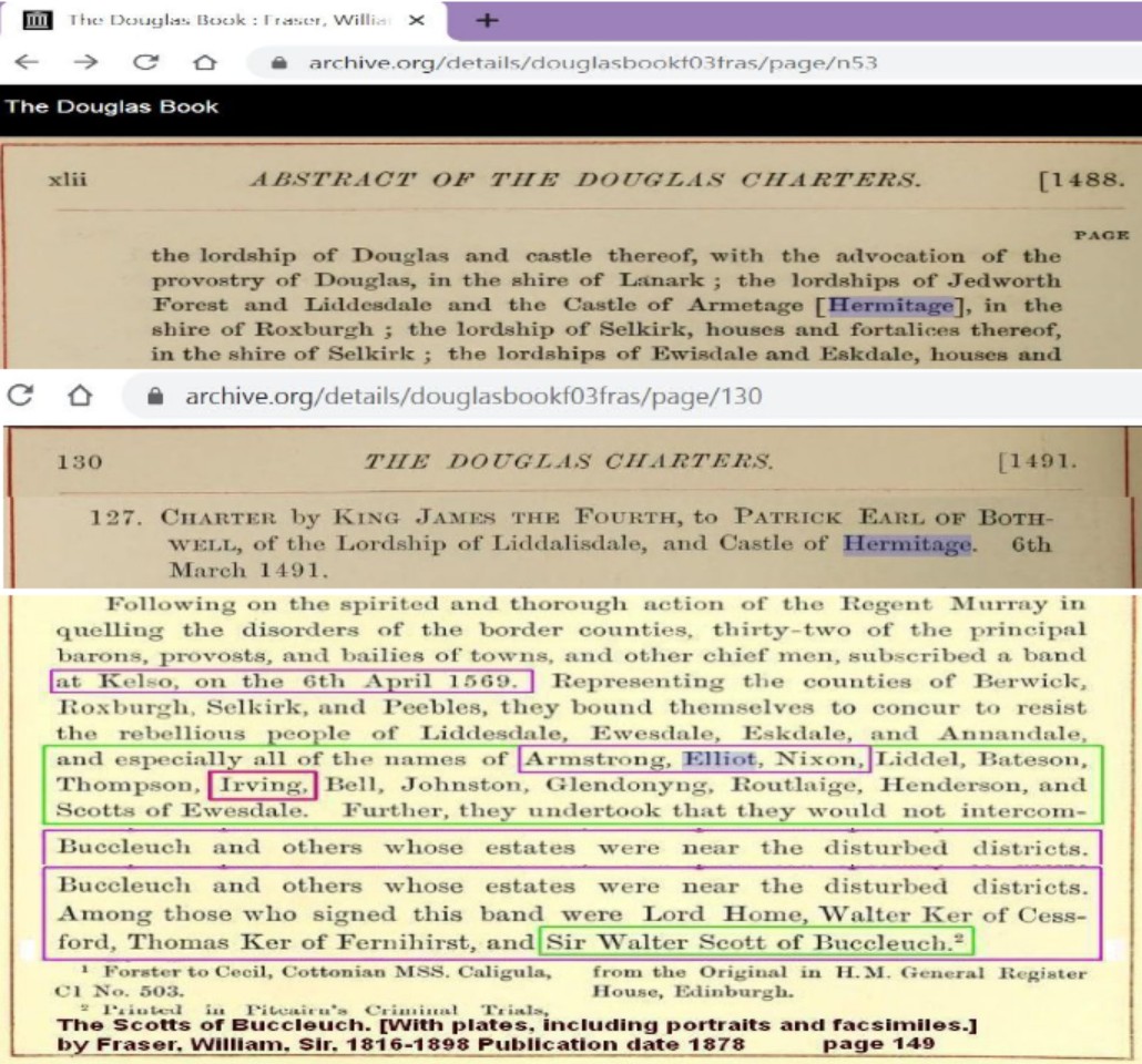
The borderers are the border army of Scotland and found on both sides of the border, and their ancestors in highest concentration still live there. To ask where the borders are today is to insinuate they are not still guarding our borders, and hopefully still protecting the Hermitage Castle like my family the Elwald/Ellot lived around and protected for the Bothwell (Hepburn) family when Bothwell was visited by Queen Mary of Scot. Though it is felt that Martin Ellot/Elwood purchase land in the north, and named it after the land which his family leased from Bothwell, near and protecting the fort, it would be said as a tenant Martin Ellot is in Braidley, and of Braidley to the land he named after an historic 1376 foresta (RB Armstrong; History Liddesdale….).
It should be noted, that the forest/wood covers the region of Old Braidlie and New Braidlie, foundations still show but covered be erosion (alluvial) . In 1376 the villages in the forest/woods of Braidlie were referred to as Lawis Superior (now New Braidlie), and Lawis Inferior (now Old Braidlie), in which the village location took on the name of the old forest.
A hill was a series of mounds. One the east side of the road between Hawick and Stobs, is a hill which has ruins on it’s knows and law (small peaks) from Hummelknows to Coklaw where the Gledstanis own land between the Scot to the west and the Douglas to the east.
Coklaw was their estate which sat on the hill above Stobs to the northeast, and had ferro-carbonaceous strata good for coking ovens to make iron. The hill which extended from Hummelknows to Coklaw, is known as Collifort Hill, because some of the knows, mounds, and laws had forts on them with coal producing facilities called a colliery, and therefore the name Collifort Hill.
Today what is called Hermitage Hill north above Hermitage Castle was in the past called a mound of a bigger hill a law. If one was of this law a possessive would be used not law’s but lawis, meaning if capitalized you were of the hill north of the Hermitage Castle such as Lawis Jok, which would mean likely a John Elwald was of what is now called Hermitage Hill. One the old map Hermitage Hill which is made up of laws, mounds, mini-peaks, and knows is east of the Hermitage Castle.
Down the Hermitage Water from the Hermitage Castle is a wooded or foresta/forested region of trees known as schaw, if your were of these trees you would be know not as schaw’s but as shawis.
So Schawis Will, would most likely be a William Elwald which lived down the Hermitage from the Hermitage Castle. The main responsibility for the Elwald/Ellot in the sixteenth century was to serve Bothwell and The Hermitage Castle as soldiers for the fort.
Mark Elliott 4/24/2015
1770 map shows Hermitage Hill as two laws towards the east not the north of the castle;

5/26/2018 MSE additions 9/9/2018
