CLAN CARRUTHERS SOCIETY (USA) – The Border Reivers- Gorrenberry.

一般財団法人 国際協力推進協会
How family members are being successful at family history;
THE FAMILY KNOWS BEST.
LISTEN TO OTHERS, ESPECIALLY PEOPLE OF THE OPPISTE SEX, WHEN IT COMES TO FAMILY.
WHEN FINDING FAMILY DO NOT GET RID OF THE IN-LAWS EVEN IF YOU WANT TO.
FAMILIES FIGHT, THOUGH DISAGREEMENT, BOTH POSITIONS-ANSWERS ARE LIKELY CORRECT.
IF THE FAMILY’S HISTORY IS DONE PROPERLY, ONE DO NOT GET TO CHOOSE THEIR RELATIVES THEY AR BORN WITH THEM.
THE FAMILY KNOWS BEST. Anything which is presented as pasted down as family history by a member of the family is accepted as being correct. If someone not of the family line expresses it being incorrect, they may be a historian, but not a family historian.
LISTEN TO OTHERS, ESPECIALLY PEOPLE OF THE OPPISTE SEX, WHEN IT COMES TO FAMILY.
People of the opposite sex see things differently and will offer a different perspective when seeking information about family.
WHEN FINDING FAMILY DO NOT GET RID OF THE IN-LAWS EVEN IF YOU WANT TO. If there are relatives that you do not want to be related to, put them in because they may be linked to relatives you want to be related to.
FAMILIES FIGHT, THOUGH DISAGREEMENT, BOTH POSITIONS-ANSWERS ARE LIKELY CORRECT. Any information you may receive is helpful, and is likely as correct as ones own.
IF THE FAMILY’S HISTORY IS DONE PROPERLY, ONE DO NOT GET TO CHOOSE THEIR RELATIVES THEY AR BORN WITH THEM. (self explanatory).

مدرسة الكويكرز الفلسطينية التي صمدت 150 عامًا من الحرب والاحتلال – كويكر سبيك
تأسست مدرسة أصدقاء رام الله عام ١٨٦٩ على يد اثنين من الأصدقاء من نيو إنجلاند، حين كانت فلسطين لا تزال تحت الحكم العثماني، وتوسعت لاحقًا لتضم حرمين جامعيين في مدينتي رام الله والبيرة المتجاورتين. وقد أجرت QuakerSpeak مؤخرًا مقابلات عبر تطبيق زووم مع رانيا معايه، مديرة المدرسة، وعمر تسديل، أمين مجلس أمنائها.
صمدت المدرسة لعقود من العنف خلال الاحتلال الإسرائيلي للضفة الغربية، بل وتعرضت لهجمات في بعض الأحيان، لكنها ما زالت مزدهرة. يقول عمر: “عندما يبدو الأمل معدومًا، نسعى جاهدين لتوفير ملاذ آمن يشعر فيه الناس بالترحيب والحرية، بينما هم خارج أسوار المدرسة ليسوا أحرارًا على الإطلاق”.


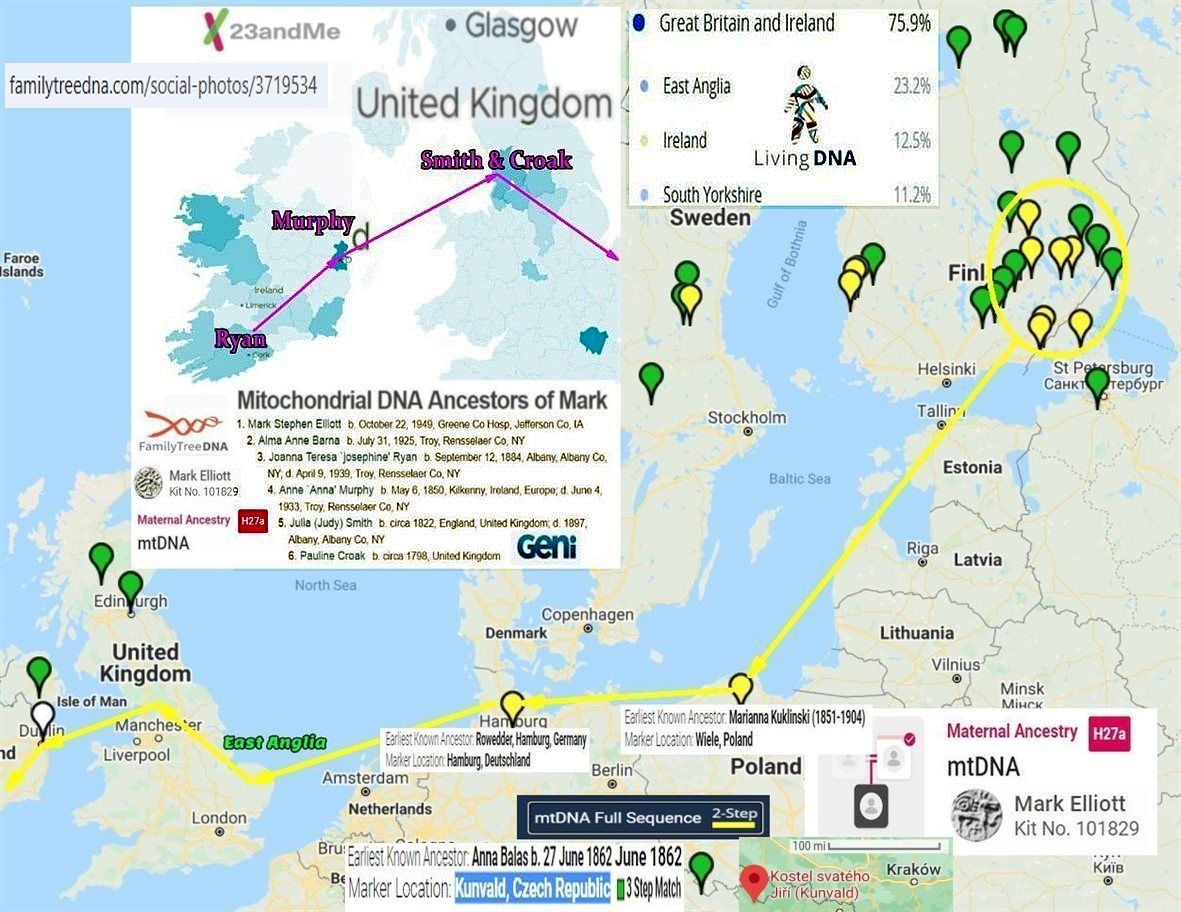
Family Tree DNA social photos 3719534 (1181×912)


American Friends Service Committee – Speed read – NobelPrize.org

Family Tree DNA social photos 3730883 (1180×884)
Family Tree DNA social photos 3712452 (1180×598)
Поскольку у меня нет доступа к набору FTDNA №101829, пожалуйста, используйте набор YSEQ №4069, чтобы найти для меня семейного историка Марка Стефан Эллиотта.

Family Tree DNA social photos 3730883 (1180×884)
Family Tree DNA social photos 3712452 (1180×598)
Поскольку у меня нет доступа к набору FTDNA №101829, пожалуйста, используйте набор YSEQ №4069, чтобы найти для меня семейного историка Марка Стефан Эллиотта.


Family Tree DNA social photos 3730883 (1180×884)
Family Tree DNA social photos 3712452 (1180×598)
Поскольку у меня нет доступа к набору FTDNA №101829, пожалуйста, используйте набор YSEQ №4069, чтобы найти для меня семейного историка Марка Стефан Эллиотта.


Michael Moore: English Civil War: Battle of Worcester 1651 | PBS LearningMedia

Westmorlandia_Cumberlandia_Atlas-Saxton 1576 mP.jpg (8880×7001)


Westmorlandia_Cumberlandia_Atlas-Saxton 1576 mP.jpg (8880×7001)


Fathers-Father-4-Robert-Elliot-and-Colonial-Maine-Royalists.pdf MSE
Chasing-my-Y-DNA-part-28.pdf MSE

Difficult to Transcribe plus Confusion and a Result with Clarification-1.pdf MSE-7-19-2012


Graham Grantham Ancient Roman J-M267 DNA – Gorrenberry


File:Sasine deed 1484 for Robert Elwald (Elliot), Redheugh, Larriston, Hartsgarth.jpg – Wikipedia
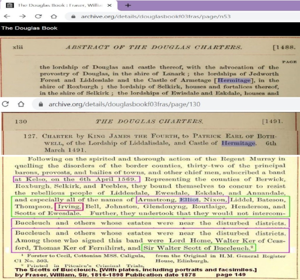
Armetage-Hermitage-Armestrang-Armstrong-Castle-Bothwell.jpg (1030×960)


FTDNA–social-photos-3719534.jpg (1181×912)


A true and exact history of the island of Barbados | Project Gutenberg


Scottish Poetry Selection – Wha Daur Meddle Wi’ Me?
The royal coat of arms in Scotland has the Latin motto “Nemo me impune lacessit“. The English translation of this is “Nobody interferes with me with impunity” and this is often defiantly expressed in broad Scots as “Wha daur meddle wi’ me?” which is the title of this anonymous poem. But on this occasion it is being aggressively repeated by a member of the Elliot family, one of the Border families who not only fought their neighbours but were part of the first line of defence against marauding English invaders – and could sometimes defy the Scottish monarch as well!


File:Sasine deed 1484 for Robert Elwald (Elliot), Redheugh, Larriston, Hartsgarth.jpg – Wikipedia

File:Crozier and Elliot in Upper Liddesdale Blaeu 1654 map.jpeg – Wikipedia


https://www.familytreedna.com/social-photos/3719534


Tullykelter-to-America 3/1/2012 Mark Elliott PDF


Die Riding Clans in Ulster von Robert Bell PDF


File:Sasine deed 1484 for Robert Elwald (Elliot), Redheugh, Larriston, Hartsgarth.jpg – Wikipedia


Elwald-de-Armstrong PDF


Peace On The Border
After the riding we dispersed We drifted home in twos and threes Through cold and rain we spat and cursed This ancient war of families


In Barbados Anglican-Royalist Scot POW from the English Civil War 1650 were indentured to the Barbados Plantation, this a precursor to the African slaves.


В этот бесценный момент во всей истории человечества все люди на этой Земле поистине едины – едины в своей гордости за то, что вы сделали, и едины в своих молитвах о вашем благополучном возвращении на Землю.
АСТРОНАВТ АРМСТРОНГ. Спасибо, господин Президент.


 Musical instruments. Pt. I. The Irish and Highland harps : Armstrong, Robert Bruce : Free Download, Borrow, and Streaming : Internet ArchiveThe History of Liddesdale, Eskdale, Ewesdale, Wauchopedale and the … – Robert Bruce Armstrong – Google Books
The harp on the royalist flag symbolizes the Gaelic-Irish-Scots. US President Donald Trump’s mother comes from this line, and golf is a Scottish game. The Gaelic-Irish-Scots welcomed us border dwellers after the death of Queen Elizabeth I. Robert Bruce Armstrong published books on the harp and the Scottish-English Border.


 About – CLAN CARRUTHERS SOCIETY (USA) (clancarruthersusa.org)


,_Redheugh,_Larriston,_Hartsgarth.jpg)
The border Reivers
(Gorrenberry-area 1st part)
The Armchair Archaeologist….

This is the Hermitage Valley from Timothy Pont’s survey of Liddesdale, circa 1583.
For ten years, from 1978 until 1988, my family and I lived at Dinleyhaughfoot, just above the “tower” marked as “Graistounhauch” on the map above, and I know this area well.
But back in those days, there was no “Google Earth,” and almost all of the overflight photographs were held by the Ministry of Defence, and “classified.”
Back in the 16th century, it is reputed that “Liddesdale” could field 3000 riders, and whilst I have commented elsewhere that this figure may have been exaggerated, due to the same riders being counted several times over, depending upon which “warlord” (sic) led the raid…… i.e on some occasions the riders were Armstrong’s (men) and not Armstrongs, (surname) and on the next the same men were Elliot’s (men) and not Elliots,(surname). That still means that Liddesdale, over the centuries was a heavily populated, even an overpopulated valley.
So…… Where are they all…. and where are all of those many thousands of burials?
Where are all of the towers, and other habitations?
Well….. No-one knows…. And the reason, in the main, is that no-one has really bothered to look!
Which is truly tragic. Because the people who were cleared out of this and other valleys, on both sides of the “Border Line” around the time of the Union of the Crowns, were some of the most dynamic people Britain ever produced, and they went onwards and outwards, throughout the world.


The “Borderers” were hugely responsible for the early colonisation of what is now the United States, and formed a very large contingent in the push west across that Continent.
And yet in their own homeland, because the clearance was so efficient, they are largely forgotten.
The Borderers as an ethnic grouping have almost disappeared, swamped out (in Scotland) to a great extent by the spread of the “Highland Image” of the Scot.
On the English side of the line, perhaps the last remnant is the “Geordie.”
And Tyneside to this day boasts a very large number of the old Border “surnames.” Mostly, because those who didmanage to remain after the clearances of the 16th and early 17th centuries, were forced off the land due to the mechanisation of farming in the 19th and 20th centuries, and they ended up in the mines, steelworks, and shipyards of Tyneside.
But now…… Thanks to modern technology, it is possible to sit at home, and to look for the very locations where the old time reivers actually lived!

This is a satellite shot of “Lada” just to the left of Hermitage Castle on Pont’s map. (or at least I think it is. It has never been excavated.)
The house outline is around thirty feet long, and it lies on a “dry mound” just above a stream.
Look carefully, and you can make out a rectangular field enclosure just below the house.
I was told years ago, that this was one of the locations occupied by “The Croziers.” So if that is you… then you may just be looking at the Ancestral Estates! And there is a fair bet, that some of your forebears are lying there, looking up, from just under that turf….. not too far away at all.
(Bet that makes the hairs on your arms stand up and prickle!)
You know, if this was in the USA……. Native American…… First Nation….. whatever, then all of this valley would be protected, at least until it was properly recorded….. But it’s not…. and so it isn’t!
“Lada” is fairly typical of a Liddesdale “dwelling”….. not a tower at all….. just a small farmstead! And the valley ought to be littered with them. The problem is, that they are hard to see at most times of year, due to an overgrowth of bracken.

This is “Graystone Haugh”……. and Graystone Haugh Tower ought to be visible just to the left of the yellow text. But it isn’t……
Back in the 1980’s you could still see it, but since then, too many tractors have been over the site, and now it’s gone forever!
And that is the danger. Forestry, Farming, Windfarms. None of which, are particularly friendly to archeology. And without any doubt at all there is a marked reluctance amongst both landowners and councils to record what sites there are.
Go out there, and the last person you are likely to meet is an archeologist!
But here is a little bit more…….

Here is the chapel just to the west of Hermitage Castle. The “Lady’s Well” is more ore less where marked, but so overgrown that I fell into it last time I was down there!
All of that just to the west is pretty much unexplored. The house platform, and rig cultivation is another typical “Liddesdale” dwelling.
The “Drowning Pool” is where the “Cout of Keilder” was allegedly held underwater by the spears of wicked Lord de Soulis’s men.

Another of Hermitage Chapel.

These are ancient turf walled field systems at “Toftholm Knowes” on the hillside south of Hermitage Castle.

And this is a piece of hillside west of Toftholm Knowes.
I’m not sure what all of that is, but it deserves a better look.
“Stells” (the word comes from the Vikings) those stone enclosures, round and square, to herd sheep into are often built out of the remains of stone houses, since no-one liked to carry stone far. The light brown stuff is dried out bracken.
There could be “rig marks” i.e strip cultivation within that open sided rectangular enclosure?
(By now you will have realised that at least some of those old “reivers” were also growing a few “veggies?”)
And this sort of thing just goes on and on.
It’s tragic really, because given time and enthusiasm, it ought to be possible not just to locate all of those old towers and farmsteads, but also it ought to be possible to say just what families lived there. So…. If you are an Armstrong, Elliot, Nixon, Crozier etc., then you ought to be able to go and stand within the outline of the houses that your families once occupied.
But you can’t.
Yet all is not lost, because the Scottish Government, in a strange fit of generosity, has made all of the old maps available, “free gratis” via NLS MAPS! Now combine this with Google Maps, and without moving from your computer you can do your very own research!
Believe me, NLS Maps is one of the best resources ever. But if you want hard copy of the Pont Series on the Border…. Well, we actually do have copies for sale ourselves!
But scroll back to the map at the beginning of this post. See the two towers at the top of the frame? The ones marked “Goranberry.” Well, life is full of little surprises, because although the right hand one is gone without trace……. here are a couple of photo’s of what remains of the other one……..


A much altered, and considerably modernised “Liddesdale Bastle House.” (Foundations and other “lower bits” probably dating back to the 16th century.
(The “Bastle house” is a sort of “economy version” of the better known and much larger “Pele or Peel Tower….. I’ll try and cover all of that in a later posting.)
Friends of mine used to live here, and farmed the land. You go up them stairs, and back down again into the lower storey.
It’s not recorded by the Historic people up in Edinburgh, but there is little doubt that this is the tower on Pont’s map.
There was a more original one at Toftholm, (on the bottom right of the Pont map.)
That wasn’t recorded either. It was used as a byre, and was demolished around 25 years ago!
Anywhere else in Britain, and it wouldn’t matter so much. But the people of Liddesdale are something of a “lost tribe” (like most of the Border Surnames), and we know almost nothing about them, or their culture. And that above is probably the only remaining inhabitable “bastle house” in the valley.
If you’ve read my earlier post “Hermitage Castle, in the footsteps of the Artists,” then you will also be aware of the “Gorrenberry Kelpie.”
I’ve had many a cup of coffee in that little “bastle” and if you have a feel for such things….. Well all I can say is that it has an “atmosphere”which is second to none. (And a pleasant one at that!)
And that’s a fine stone dwelling for 16th century Liddesdale, and proves that not everyone lived in relatively small turf houses.
That little building is precious, almost unique……..a gem well worth preserving.
11th February, 2014.
Just a small update.
 Speculation?
The “bastle” at Old Gorrenberry is just below the “d” in “Old.”
Sooo…… I pulled up the map again, and had a look for Mosspatrickhoopswyne, and Ginglenwells, because, due to the topography of the land, there are not many locations where they could be situated.
The land falls away from “Old Gorrenberry” both to the top and bottom of that frame. It falls to the two burns, and then rises sharply into quite considerable hills.
Remember that I said that they didn’t carry stone far to build those “stells,” and that they sometimes dismantled derelict houses to do so?
Well, pull that frame up on your computer, and have a good close look…..Mosspatrickhoopswyne…. (some mouthful that one is)…. probably lies below, and to the left of the capital “M” above.
And Ginglenwells, is probably below and to the right of the centre of the word itself. There could just be a rig cultivation system visible there, but on the other hand it may just be drainage.
But of course…. you must make your own minds up.
And I have no doubt at all that some archeologist will be spluttering in their coffee over all of this!
Whatever…. It looks like a good afternoon out when the weather gets fine, and I get rid of this flu!
14th of February 2104.
Still stricken down with “lurgi,” but we had to drive down to Newcastleton (Copshawholme to you initiates) yesterday to pick up some paperwork, so we decided to take the scenic route.

And this is an “on the ground” view of “Ginglenwells.”
It was a difficult drive, over higher ground than this, and we were up above the snow line for quite a way. The family played hell with me for even going out but as they saying goes… “you can’t keep a bad man down!”
Funny how those satellite shots flatten all of the landscape.
And I photographed this, around three hundred yards west……

Now, once again, that has the look of a Liddesdale dwelling….. raised ground…. near stream…. reasonably flat…. stell….. and this one even has a track up to it. So I’ll put that one on the list as well for me “day out.”
